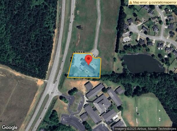
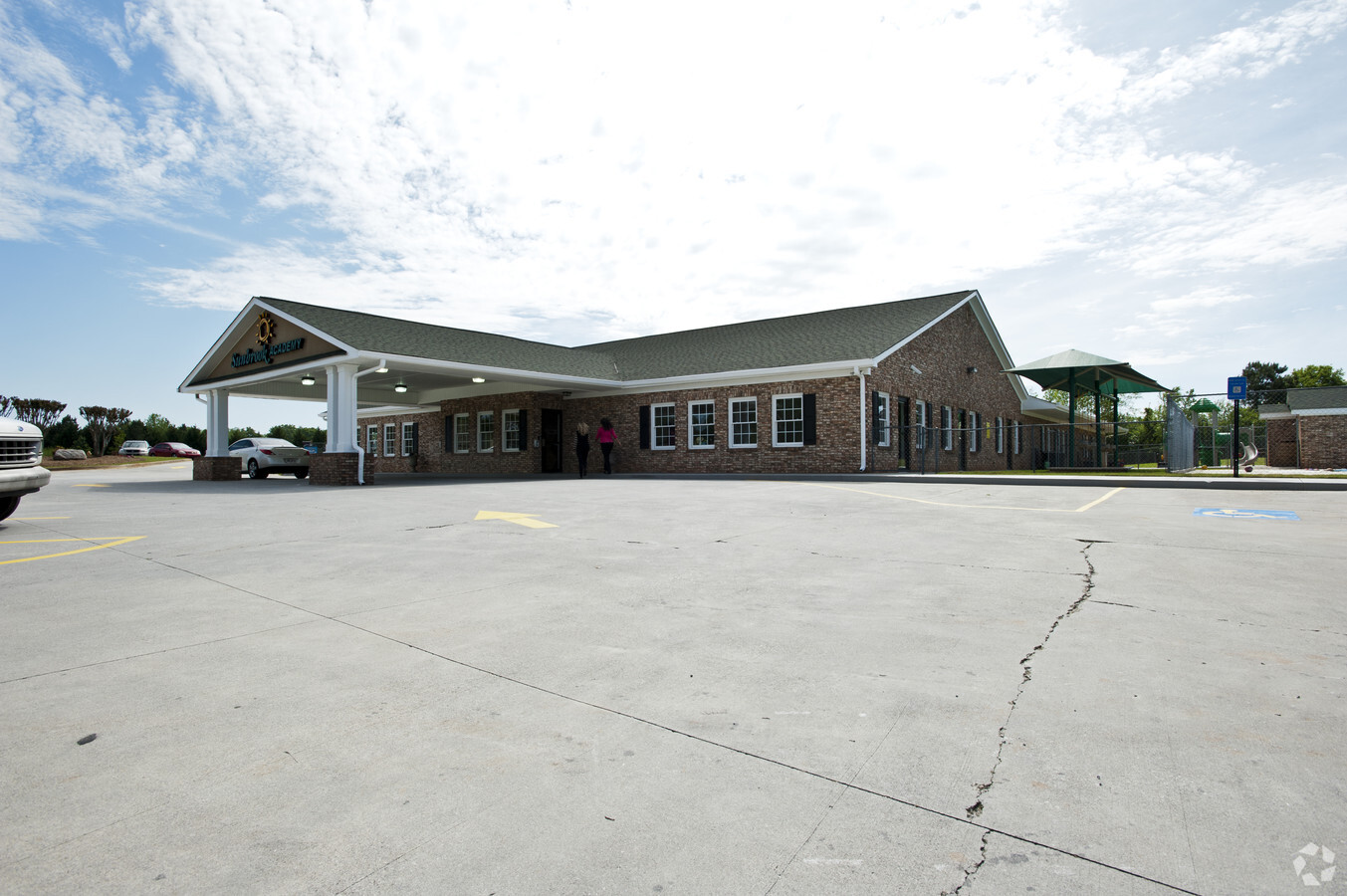
Property Record
501 Bay View Dr, Villa Rica, GA 30180

NEARBY LISTINGS FOR SALE OR LEASE
Property Detail
501 Bay View Dr
V07-0140010
Comm Bldg/199Ac Bay View Dr
Daycare
COMM BLDG/1.99AC BAY VIEW DR CTY169
X
Carroll
13045C0154D
Georgia
2024
1.99 AC
2024
Villa Rica/W Outlying
910103
Atlanta
9,380 SF
Atlanta-Sandy Springs-Roswell, GA
DEMOGRAPHICS near 501 Bay View Dr
1 Mile
3 Mile
5 Mile
2024 Total Population
1,564
12,455
40,170
2029 Population
1,749
13,851
44,156
Pop Growth 2024-2029
+ 11.83%
+ 11.21%
+ 9.92%
Average Age
36
37
38
2024 Total Households
568
4,525
14,402
HH Growth 2024-2029
+ 11.97%
+ 11.38%
+ 10.12%
Median Household Inc
$84,127
$66,312
$72,754
Avg Household Size
2.80
2.70
2.70
2024 Avg HH Vehicles
2.00
2.00
2.00
Median Home Value
$208,955
$219,407
$236,147
Median Year Built
2003
2001
1998
Nearby Places
- Restaurants
- Banks
- Shops
- Fitness
- Groceries
PUBLIC TRANSPORTATION
AIRPORT
Hartsfield - Jackson Atlanta International
DRIVE
WALK
Distance
Hartsfield - Jackson Atlanta International
56 min
43.6 mi
Freight Ports
Georgia Ports - Savannah
DRIVE
WALK
Distance
Georgia Ports - Savannah
319 min
282.9 mi
Nearby Properties
Address
Land Use
TOTAL SIZE
Lot Size
Zoning
Address
Land Use
TOTAL SIZE
Lot Size
Zoning
205,390 SF
24.28 AC
Address
Land Use
TOTAL SIZE
Lot Size
Zoning
69,664 SF
24.09 AC
R14
Address
Land Use
TOTAL SIZE
Lot Size
Zoning
279,840 SF
44 AC
DCD
Address
Land Use
TOTAL SIZE
Lot Size
Zoning
10,990 SF
20.40 AC
R14
Address
Land Use
TOTAL SIZE
Lot Size
Zoning
310,689 SF
36.51 AC
LI
Address
Land Use
TOTAL SIZE
Lot Size
Zoning
164,061 SF
16.96 AC
GC
Address
Land Use
TOTAL SIZE
Lot Size
Zoning
111,860 SF
12.29 AC
Address
Land Use
TOTAL SIZE
Lot Size
Zoning
15,949 SF
9.01 AC
R14
Address
Land Use
TOTAL SIZE
Lot Size
Zoning
266,422 SF
16.35 AC
GI
Address
Land Use
TOTAL SIZE
Lot Size
Zoning
30,951 SF
28 AC
R20
Address
Land Use
TOTAL SIZE
Lot Size
Zoning
103,129 SF
19.50 AC
GC
Address
Land Use
TOTAL SIZE
Lot Size
Zoning
7,630 SF
14.27 AC
R14
Address
Land Use
TOTAL SIZE
Lot Size
Zoning
11,454 SF
1.77 AC
GC
Address
Land Use
TOTAL SIZE
Lot Size
Zoning
16,310 SF
2.16 AC
PD
Address
Land Use
TOTAL SIZE
Lot Size
Zoning
112,275 SF
13.40 AC
002
Address
Land Use
TOTAL SIZE
Lot Size
Zoning
45.97 AC
LI
Address
Land Use
TOTAL SIZE
Lot Size
Zoning
8,287 SF
1.03 AC
GC
Address
Land Use
TOTAL SIZE
Lot Size
Zoning
9,158 SF
4.15 AC
DO-COM
Address
Land Use
TOTAL SIZE
Lot Size
Zoning
7,000 SF
25.83 AC
1
Address
Land Use
TOTAL SIZE
Lot Size
Zoning
17,280 SF
2.25 AC
GC
Address
Land Use
TOTAL SIZE
Lot Size
Zoning
29.08 AC
GI
Address
Land Use
TOTAL SIZE
Lot Size
Zoning
77,650 SF
8.78 AC
GC
Address
Land Use
TOTAL SIZE
Lot Size
Zoning
20,373 SF
9.98 AC
C
Address
Land Use
TOTAL SIZE
Lot Size
Zoning
5,204 SF
2.15 AC
GC
Address
Land Use
TOTAL SIZE
Lot Size
Zoning
60,594 SF
7.05 AC
GC
Address
Land Use
TOTAL SIZE
Lot Size
Zoning
64,597 SF
9.05 AC
GC
Address
Land Use
TOTAL SIZE
Lot Size
Zoning
55,748 SF
8.53 AC
CBD
Address
Land Use
TOTAL SIZE
Lot Size
Zoning
8,026 SF
1.15 AC
GC
Address
Land Use
TOTAL SIZE
Lot Size
Zoning
32,052 SF
11.63 AC
R14
Address
Land Use
TOTAL SIZE
Lot Size
Zoning
29,284 SF
4.40 AC
OI
The World's #1 Commercial Real Estate Marketplace
Connect with us
© 2025 CoStar Group
The information above has been obtained from sources believed reliable. While we do not doubt its accuracy we have not verified it and make no guarantee, warranty or representation about it. It is your responsibility to independently confirm its accuracy and completeness. Any projections, opinions, assumptions, or estimates used are for example only and do not represent the current or future performance of the property. The value of this transaction to you depends on tax and other factors which should be evaluated by your tax, financial, and legal advisors. You and your advisors should conduct a careful, independent investigation of the property to determine to your satisfaction the suitability of the property for your needs.